 |
 |
Which projection do you prefer?
Poll
| 4 votes (66.66%) | |||
| 1 vote (16.66%) | |||
| 1 vote (16.66%) |
6 members have voted
| May 13th, 2016 at 5:04:14 AM permalink | |
| Fleastiff Member since: Oct 27, 2012 Threads: 62 Posts: 7831 | Sorry someone undid your work, perhaps both projections should be put up so as to keep atleast someone happy. |
| May 13th, 2016 at 10:39:27 AM permalink | |
| Pacomartin Member since: Oct 24, 2012 Threads: 1068 Posts: 12569 |
 I cut it down to one rectangular projection, but limited it to top 5 (instead of top 10). None of the top 5 are polar routes 3 Jun 2009, Atlanta-Johannesburg on Delta Air Lines (8,439 miles) 29 Sep 2014, Dallas/Fort Worth-Sydney on Qantas (8,578miles) 2 Mar 2016, Auckland-Dubai on Emirates (8,825 miles) 1 Jun 2016, San Francisco-Singapore on United (8,446 miles) WILL TAKE OVER RECORD FOR LONGEST US AIRLINE ROUTE 2 Feb 2017, Auckland-Doha on Qatar Airways (9,032) WILL TAKE OVER RECORD FOR LONGEST CURRENT COMMERCIAL ROUTE 28 Jun 2004, Newark to Singapore on Singapore Airlines (9,535 miles) discontinued 23 November 2013 LONGEST COMMERCIAL FLIGHT IN HISTORY The B777-200LR advertises a range of 10,900 miles under ideal weather conditions, but no commercial airline would schedule a route that long. Personally, I have never flown over 5,938 miles in one leg |
| May 13th, 2016 at 10:57:48 AM permalink | |
| petroglyph Member since: Aug 3, 2014 Threads: 25 Posts: 6227 | Maybe it was one of the flat-earthers? Which projection are NOAA Bathymetric charts? I like those or topo maps. Why is it so hard to find a good road atlas nowadays? It seems the printing is frequently in Mauve, which is hard to see when it is new. It fades really fast. I have searched for quality maps of the S.W. US but haven't found anything I like in 10 years. The last official act of any government is to loot the treasury. GW |
| May 13th, 2016 at 12:21:16 PM permalink | |
| Ayecarumba Member since: Oct 24, 2012 Threads: 89 Posts: 1744 |
it doesn't seem right that one person can simply impose their preference. What if ten folks like the polar projection and only one doesn't? |
| May 13th, 2016 at 12:48:02 PM permalink | |
| Pacomartin Member since: Oct 24, 2012 Threads: 1068 Posts: 12569 |
You are supposed to build a consensus, but you usually only have a few people. The reality is the Mercater projection has been around for 450 years and while it is distorted, it is what people are used to. People tend to think that Greenland is huge, when in fact it is smaller than Argentina.  But 450 years ago, there was no way to calculate longitude. If you sailed you tended to follow a line of latitude so you didn't get lost at sea. It was obviously more important than sailing the shortest distance. Very small percentage of the world's population lives in the southern temperate zone (between the tropic of capricorn and antartic circle, so most maps move the equator down, and many cut of the top and bottom 12 degrees. 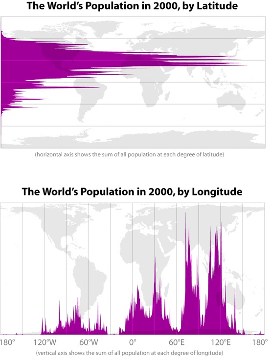 So people tend to vote for the projection they've seen their whole lives |
| July 29th, 2016 at 12:49:04 PM permalink | |
| Nareed Member since: Oct 24, 2012 Threads: 346 Posts: 12545 | I recently came across an article comparing the latitude of various places in the Western hemisphere and how they correspond to the Old World. On that basis, it would be very useful to make a projection that preserved the respective latitudes. It would help better understand why so many flights to Europe from North America have to head as much north as east. It's really odd to see flight routes on the current projections. A flight from Mexico or Houston to London, Paris or Amsterdam, spends about as much time moving north across the US and a bit of Canada as it does over the Atlantic. Donald Trump is a one-term LOSER |