 |
 |
Is the Four Corners memorial in the right place?
Poll
| No votes (0%) | |||
| No votes (0%) | |||
| No votes (0%) | |||
| No votes (0%) | |||
| 2 votes (66.66%) | |||
| No votes (0%) | |||
| No votes (0%) | |||
| No votes (0%) | |||
| No votes (0%) | |||
| 1 vote (33.33%) |
3 members have voted
| May 22nd, 2021 at 5:19:29 PM permalink | |
| Wizard Administrator Member since: Oct 23, 2012 Threads: 239 Posts: 6095 | I've always been confused by the controversy if the Four Corners Memorial is in the right place. It is a rather complicated story. In 2009 the Associated Press evidently reported the memorial to be 2.5 miles off and multiple other sources repeated the error. Here is one example. Four Corners spot is off the mark from the 4/20/09 Denver Post. However, even today, if you zoom in on Google Maps (see image below), it shows the disk to be about 40 feet off the intersection of the boundaries. 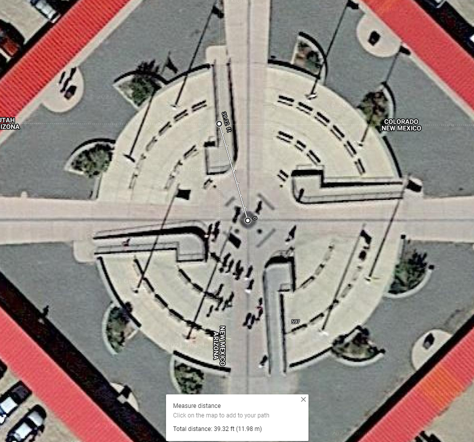 I have Google'd this and recent articles say things like the current memorial is legally in the right spot, but not geographically. Huh? I am very anal about stuff like this. How can it be legally right but not geographically? Here are some quotes:
Source: The Four Corners Is The Only Quadripoint In The Country, But It�s Not Where You Think It Is
Source: Why the Four Corners Monument is in Exactly the Right Place Can anyone please explain to me what is really going on? The question for the poll is whether the marker or Google is wrong (multiple votes allowed). Knowledge is Good -- Emil Faber |
| May 23rd, 2021 at 3:22:38 PM permalink | |
| AZDuffman Member since: Oct 24, 2012 Threads: 135 Posts: 18210 |
I can answer a bit from my landman work. This is clearly way larger scale, but the process is similar. First thing will sound like it is in conflict. When you do a survey you start from some kind of known mark. I said her once that the top point of WV where it meets OH and PA is the start of almost every survey between there and the Rockies. Every six miles is a "range" and at that range you will have a marker to start the next set of townships and sections withing the townships. Now, an entire state must have some more permanence than a six by six mile township, but the process is still the same. Way, way back a survey team would have put an iron pin or other marker every so far and that is supposed to be the straight state line. Except it will be a tad wavy for reasons from not perfect equipment to uneven land to drunk surveyors. Then there is the changing magnetic declination. I have seen surveys that state the bearings are of such and such a date. I have plotted lands that were re-surveyed and do not quite match up. These are 200 or so acre plots. The USA Geological Survey will strive for more accuracy, but it also is a tens of thousands larger scale. Now, you would also be amazed how many surveys are set based on something smaller of permanence. Like you have your neighborhood and the property line matched up with this or that and people do not worry about a few inches for the most part. Somewhere in your neighborhood is the "monument" that it all starts from, if you had to you could replot all the lots. But out in the middle of nowhere, you do not have these markers. Maybe a mile away. We are talking about land owned by the feds for the most part so they do not really care about the exact state line. Other land is owned by the states and again, until people move there or mineral rights matter a few feet is not of high concern. Now that I have beat it into the ground, my answer is it is near impossible that it is "exact" based on the borders as laid out by law when the territories were laid out in the organic acts. But that being said the monument IS the border even if it is not geographically sound. Even the shifting of the entire continent will move it. Now, a bonus for Wizard, the only guy I have ever know who might be more fixated on Four Corners and Northwest Angle than I am. Yet more oddities of land borders. Another example of what happens when borders shift. The President is a fink. |
| May 23rd, 2021 at 11:49:50 PM permalink | |
| Wizard Administrator Member since: Oct 23, 2012 Threads: 239 Posts: 6095 | Thanks for your comments AZD. I learned a fair but about surveying from it. From the articles I mentioned in my OP, I understand that even if an official government survey marker for purposes of a state border is a little off, it trumps where the actual border should be. What that suggests to me is the actual latitude and longitude lines should be adjusted slightly to match the marker. This seems to have actually happened with the border of Colorado and Utah, but perhaps not correctly.  Notice how Utah seems to take a little triangle out of Colorado. I suggest they do the job properly and draw the borders so that they meet at the exact middle of the geodesic marker at the four-corner memorial. Or did they and Google is wrong? Here is my practical question -- If I move one foot directly north from the marker, which state would I be in? Here is one you might appreciate -- the world's smallest park, in Portland OR. Knowledge is Good -- Emil Faber |
| May 24th, 2021 at 12:24:12 AM permalink | |
| Wizard Administrator Member since: Oct 23, 2012 Threads: 239 Posts: 6095 | To reply to myself, if you right-click on the marker on Google maps (not where the borders meet), you get these coordinates: 36.99898 -109.04519 Then put those coordinates in https://latitude.to/lat/36.99898/lng/-109.04519, you get what seems to be the proper location for the marker, although it is accurate to what looks like feet but not inches. This image is as much as you can zoom in. 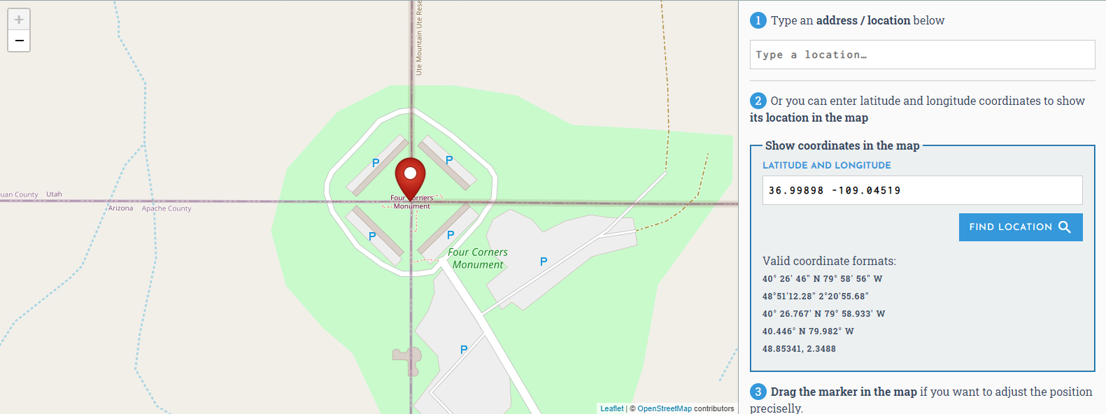 To get yet another opinion, MapQuest seems to agree with Google Maps.  I am inclined to think that Google and MapQuest are not drawing the state borders correctly. As evidence to that claim, note the wonky border at the Hoover Dam on Google Maps compared to the nice clean one at Latitude.to. 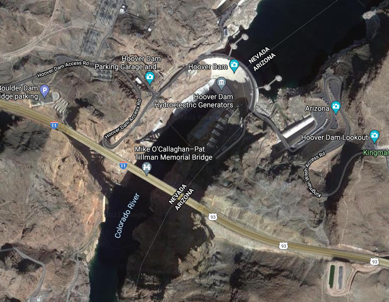 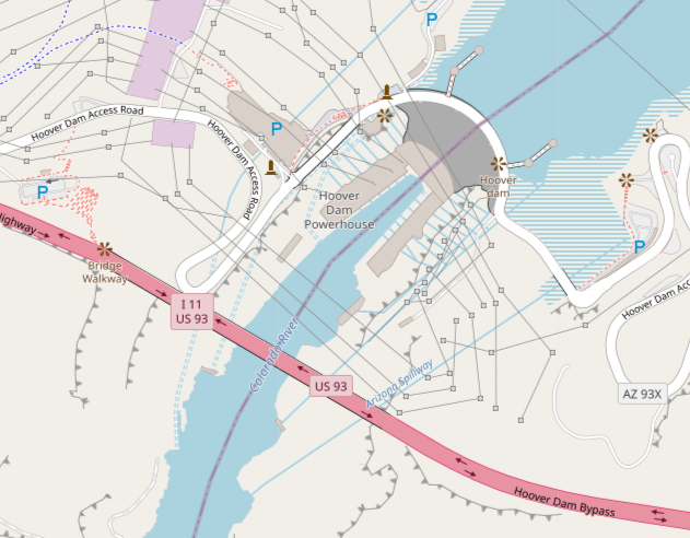 Knowledge is Good -- Emil Faber |
| May 24th, 2021 at 8:08:12 AM permalink | |
| AZDuffman Member since: Oct 24, 2012 Threads: 135 Posts: 18210 |
You would be amazed how many people do not know what a survey even is! George Washington was a surveyor by trade. That people I have talked to would not know the term amazed me. The thing is moving the de facto line to the "correct" position can just cause issues. You could move a line and it then bisects someone's land. I have in my time dealt with properties that straddle counties. In one case for 100+ years no records were kept in the second county. The recital when they cleared it up was 15 pages long! Usually they are one sentence. EDUCATIONAL STUFF: A "recital" is a line in the deed that shows where the property was obtained. It is sometimes called the "being clause." Example, if Donald Trump had to sign the WH to Joe Biden it would say, "Being the same property granted to Donald Trump from Barack Obama at Deed Book X, Page Y." The mess of 2 counties will be nothing compared to if a state border shifts. And that is only one thing. I get wanting it to be "right" but it is just one of those things that does not solve so much. Besides, other than Skylar White getting a wrong result on her coin flip would it really matter for history? The President is a fink. |
| May 24th, 2021 at 8:36:19 AM permalink | |
| kenarman Member since: Oct 24, 2012 Threads: 14 Posts: 4515 | To me the strangest state border is the Mississippi border along the river. The river has changed course in multiple areas, many of them man made. The river was the border but when the river was moved the border stayed on the old course of river. Now you many loops cut out of one state and belonging to the adjacent state. Many with no direct access because the river is in the way. "but if you make yourselves sheep, the wolves will eat you." Benjamin Franklin |
| May 24th, 2021 at 9:07:06 AM permalink | |
| Wizard Administrator Member since: Oct 23, 2012 Threads: 239 Posts: 6095 | It gets even crazier in Europe. Here is a good example. Direct: https://www.youtube.com/watch?v=KEM_cp6hVeM Knowledge is Good -- Emil Faber |
| May 24th, 2021 at 9:30:29 AM permalink | |
| kenarman Member since: Oct 24, 2012 Threads: 14 Posts: 4515 |
Thanks Mike I didn't know anything about that anomaly. "but if you make yourselves sheep, the wolves will eat you." Benjamin Franklin |
| May 26th, 2021 at 4:32:21 PM permalink | |
| DJTeddyBear Member since: Oct 24, 2012 Threads: 5 Posts: 265 | I don't know what bothers me more: That the border has that weird bend, or that even with the bend, the point google shows (that I highlighted with the arrow) is still not in the center of the marker. But al least they put the point of interest mark in the right place. 😜 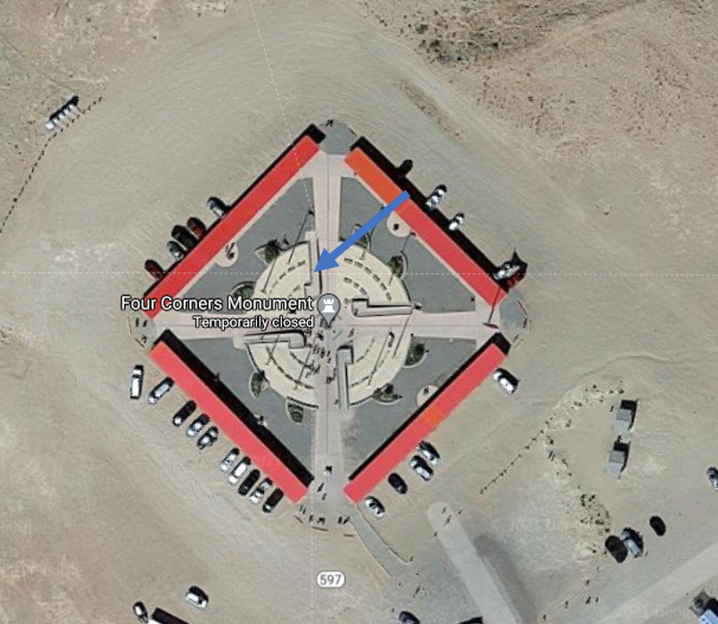 Ignorance is bliss and knowledge is power. But having only some facts can get you into trouble! |
| June 11th, 2021 at 1:11:59 PM permalink | |
| AZDuffman Member since: Oct 24, 2012 Threads: 135 Posts: 18210 |
More on reference points. The President is a fink. |